| MAPYX |
| Mapping for personal users |
|
|
|
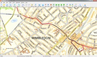
OS StreetView GBOS Street View is a generalised and simplified street-level map. It allows you to easily visualise a variety of information in its geographic context.Tiles are 10km x 10km. *Download Option only - Size 14GB.
*Note: Not currently supported on iOS - we are working to resolve this.
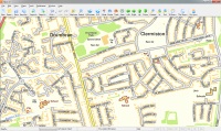
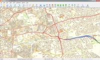
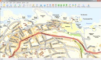
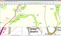
OS Street View is 1:10 000 scale street-level colour digital raster mapping that has been specifically designed to cartographically emphasise road carriageways, road names and their DfT numbers, generalised buildings and areas of vegetation.buy amoxicillin australiahow to take amoxicillin online buy amoxicillin |
 |
£ 50.00 + VAT |

buy antibiotic online
buy amoxicillinTestimonials
buy antibiotic online
buy amoxicillin|
|
|
Mark Lewis"Every recognised team and member of Mountain Rescue England & Wales will benefit from the Quo package receiving a free copy with associated maps." Mark Lewis, the Communications Officer for MREW |
|
 |
Mike Thompson"Quo Mapping by Mapyx offers something rather refreshing, as the product updates and improves it actually gets easier to use." Mike Thompson, Aqua 3 |
 |
Paul Webster"We at Walkhighlands have found Quo to be the easiest to use and most fully featured mapping software on the market." Paul Webster, Walkhighlands |
|
|
|
 |
Gavin S McKay"It is difficult to put into words just how delighted I am with your service and attention to detail." Gavin S McKay |
 |
Dave Mycroft"Quo is becoming my default mapping software after years of Memory Map." Dave Mycroft |
|
System Requirements l Privacy l Terms of Use l Delivery l Remote Assistance 

Mapyx Ltd., 8A Cranmere Road, Okehampton, Devon. EX20 1UE All rights reserved 2006-2021. |