| MAPYX |
| Mapping for personal users |
|
|
|
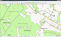
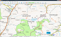
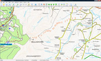
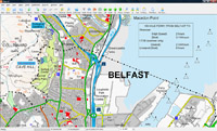
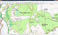
OSNi 50K Northern IrelandThe 1:50 000 OSNi map is cartographically identical to the Discoverer series(1:50 000) paper product. Making it ideal for all your outdoor planning in Northern Ireland.
Clear detailed information on roads, foothpaths, woods, water features, important buildings and height contours.buy amoxicillin australiahow to take amoxicillin online buy amoxicillin |

 |
£ 38.99 + VAT |

buy antibiotic online
buy amoxicillinTestimonials
buy antibiotic online
buy amoxicillin|
|
|
Mark Lewis"Every recognised team and member of Mountain Rescue England & Wales will benefit from the Quo package receiving a free copy with associated maps." Mark Lewis, the Communications Officer for MREW |
|
 |
Gavin S McKay"It is difficult to put into words just how delighted I am with your service and attention to detail." Gavin S McKay |
 |
Dave Mycroft"Quo is becoming my default mapping software after years of Memory Map." Dave Mycroft |
 |
Mike Thompson"Quo Mapping by Mapyx offers something rather refreshing, as the product updates and improves it actually gets easier to use." Mike Thompson, Aqua 3 |
 |
Paul Webster"We at Walkhighlands have found Quo to be the easiest to use and most fully featured mapping software on the market." Paul Webster, Walkhighlands |
|
|
|
System Requirements l Privacy l Terms of Use l Delivery l Remote Assistance 

Mapyx Ltd., 8A Cranmere Road, Okehampton, Devon. EX20 1UE All rights reserved 2006-2021. |